
Snow Report 26 Jan 2023
We’ve been enjoying a fabulous week here in the Alps with near perfect conditions, although really very cold we have sunshine, blue skies and plenty of snow around to enjoy! A sprinkling of snow was enjoyed on Tuesday but apart from that we’ve had no significant snowfall since last Wednesday. We’ve been eagerly watching the forecast for early next week, thinking we have a *Nordstau finally coming (*this is when a wandering jet stream has a more north/south pattern, with polar air able to pick up moisture from the North Sea) which should bring good snow on Monday evening. Currently, this is scaling back as there is a high pressure area to the west of The Alps, which will likely hinder this. However we are surmising on a weather situation that is still 4 days away, so quite hard to predict.
In Les Arcs it remains very cold and we have colder air coming in, peaking at -10°C on Friday afternoon with a maximum of -4°C on Monday. Generally it will remain sunny with maybe a light cloud cover at times and winds getting slightly fresher from Monday. It’s looking like we may have to wait a little longer for our top up of snow, although a few cms are forecast for Monday. Currently we have good snow conditions with an upper snow depth at the Grand Col at 3000m of around 230cm with 55cm at Arc 1600. The avalanche risk is moderate at 2/5.
The freezing level is down to 550m on Sunday night but predicted to rise to between 950m and 1250m on Tuesday.
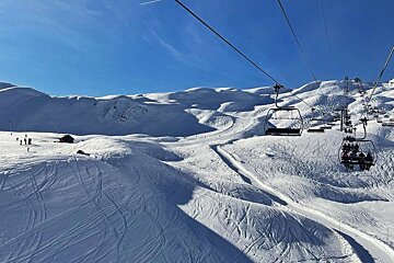
Estelle’s stunning photo above - enjoying a bluebird day on the slopes today in Les Arcs
Top Tips if you are coming skiing this week
- While the pistes are still quiet, if you head out during the lunch break between 12 and 2pm, it is often like having a private mountain to explore!
- The pistes are quite hard-packed, but the snow on the sides of the runs is often softer. Keep to the sides of the pistes for a more effortless, less icy experience.
- Pack a variety of equipment - highlight and low light goggle lenses and you'll need layers!
- If you are heading out at night, windchill is dropping the day temperatures by up to 10°C, so really keep warm and stay safe.
- Always check the avalanche risk and don't head off-piste if you don't have the correct information, equipment and guidance.
You can still grab a last minute deal to enjoy the sunshine and snow before the school holidays start.
Updates
If you head to the bottom of this page, you can see live forecasts, lift status, links to webcams, real time photos from Les Arcs. We will be updating this snow report page every Thursday, so check back in with us to see how the pistes are doing and what you can expect from the snow forecast each week.
We need you!
If you're in Les Arcs this week, we want to see your images, especially videos, of what you've been up to. So when you post to Facebook or Instagram, please tag us @SeeLesarcs #seelesarcs. Every week, we'll be posting our favourite videos and images here and sharing on our social media, along with our weekly resort snow report.
Make the most of the last couple of weeks of quieter pistes before the school holidays begin!


